
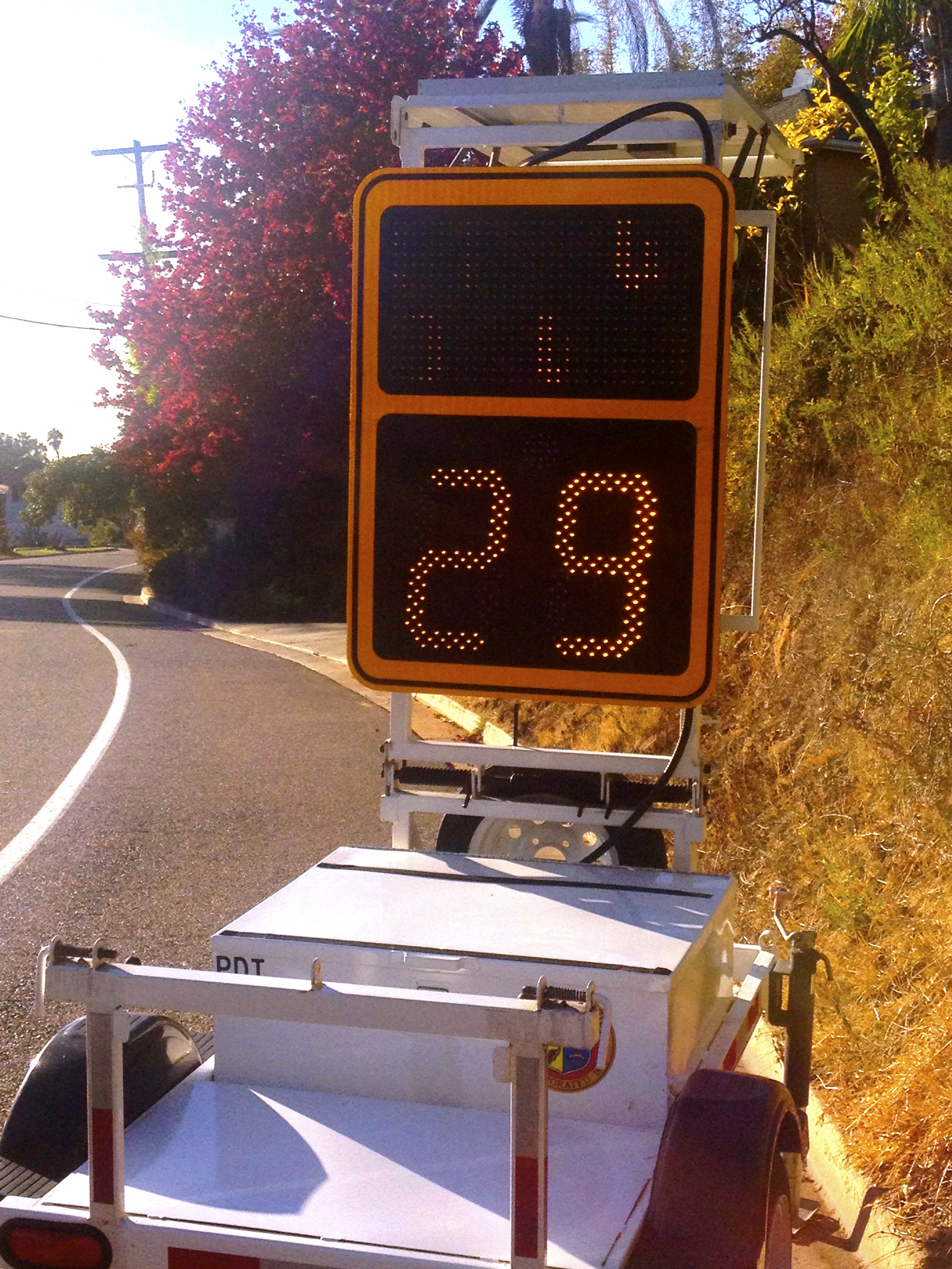
 Fire Mountain Traffic: Looks like Avocado Rd. is the latest through-street in Phase 1 of traffic calming measures. Thanks to the persistence of our neighbors the city has installed a radar trailer on Avocado Rd. and is studying the need for additional measures. Normally Phase 1 consists of “educating the public” and the radar trailer is one way to educate motorists as to how fast they are actually traveling.
Our streets become particularly dangerous during the holidays as more people cut through our neighborhood to get to the Wal-Mart shopping center, let’s hope the education process is stepped-up during that time.
Changes to Downtown Oceanside: Mission Avenue, between Horne Street and Coast Highway, started it’s update last week and will continue renovations until Summer 2014. Like many more metropolitan downtown areas the main entryway to Oceanside will become a two lane, one-way street. Mission Avenue will be converted to a west-bound only route, while Seagaze Drive, one block south of Mission Avenue, will be converted to a one-way east bound street. Let the confusion begin! For more info visit the City of Oceanside web site.
 Interstate 5 Expansion Project: The environmental impact report for the $3 billion 27-mile I-5 expansion project has been completed and hundreds of pages are now available here for download. The last public meeting in Oceanside was in 2010. Since that time the agency has heard from more than 5000 people and incorporated their comments into the planning – the improvements are focused on carpools, transit, and express lanes.
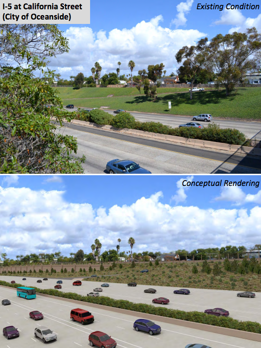
Highlights of Oceanside area changes include a couple of pocket parks, some sound barriers, The visual simulation looks as if the freeway is really encroaching on the Buena Vista Lagoon and there are major improvements to bike and pedestrian paths along all 27 miles.
The incredibly dangerous I5 / 78 Interchange is not a part of this expansion. While there are a couple of changes on the docs, that is a separate project that will move forward independently and supposedly meetings were to be scheduled Summer 2013 (Did we miss those?).
According to the web site, the I-5 Express Lanes project is just one component of the planned $6.5 billion North Coast Corridor (NCC) Program, which includes highway, rail, transit, environmental protection and coastal access improvements. Planned improvements such as the I-5 Express Lanes provide flexibility for future for transit services such as Bus Rapid Transit and highway express buses. Adding Express Lanes to I-5, double tracking the coastal rail line and improving local and regional bike and pedestrian trails are part of the NCC Program’s system solution to focus on moving people rather than just cars.
It looks like there were approximately 10 options considered and the “Preferred Alternative,” announced in July 2011, is the Express Lanes Only option (8+4 with Buffer Alternative) which “results in nearly 50 percent fewer Right-of-Way impacts and focuses on project phasing and coordination to minimize impacts to the environment and the community during construction.”
 Expect construction to start in Spring 2015 and continue through the year 2035. Construction begins on the I-5 High Occupancy Vehicle (HOV) extension from Manchester Avenue to SR 78 which will add one HOV lane in each direction from Manchester Avenue to SR 78.
We went through the multiple documents available and found the following updates that will specific to the Oceanside area. For more details and to see what’s happening in other areas, feel free to leaf through the hundreds of pages in multiple documents – it’s actually pretty interesting to see the before/after graphics depicting the visual simulations of the changes.
OCEANSIDE SPECIFIC CHANGES:
- Improvements would occur at the I-5 /SR-78 Interchange. (p.ES-10) however, this does not fully address improvements to the I5 / 78 Interchange – that’s an entirely different project and information can be found here.
- Revise various local interchanges to improve vehicular, pedestrian, and bicycle circulation at the following locations: northbound ramp for California Street; southbound ramps for Cassidy Street; (pES-37) and both north- and southbound ramps for…Carlsbad Village Drive, Las Flores Drive, SR-78, Oceanside Boulevard, Mission Avenue, SR-76, and Harbor Drive.
- The North Coast Bike Trail (NC Bike Trail) is proposed to extend from Gilman Drive in the City of San Diego, to Harbor Drive in the City of Oceanside (27 miles).
- The NC Bike Trail IN OCEANSIDE would provide enhancements to current bicycle facilities and create new community connections that currently do not exist.
- 1 – Pocket Park and Pedestrian Path at California Street –Implements “safe walk to school” principles, Provides residents separate pedestrian route along California Street, and Creates community pocket park.
- Proposed widening of existing sidewalk and addition of landscape on Oceanside Boulevard under and adjacent to I-5. Includes enhanced fencing along the Sprinter tracks (0.70 acre)
- Development of a 0.285-ac community open space park and/or community garden adjacent to the Family Recovery Center on Horne Street.
- Proposed parking area with 51 parking spaces (area of 40,605 sq ft), trailhead staging area, and other support amenities for the existing San Luis Rey bike path located on east side of I-5 /SR-76 interchange. Includes southern willow scrub and coastal sage scrub restoration. (0.84 acre, 51 parking spaces)
- Recommended Soundwalls at Las Flores, 78/I-5, Cassidy St., California, and Loma Alta Creek Bridge.
