
The full history of the Fire Mountain area has proven difficult to complete, most of it lost over time. The comments section below has created some pretty cool insight to how the area was named and how the lines have been drawn and recreated through it’s history.
Please feel free to add your comments and if you would like to contribute additional graphics or information please email Friendsoffiremountain@gmail.com
One contribution we received is this historic outline of the area.
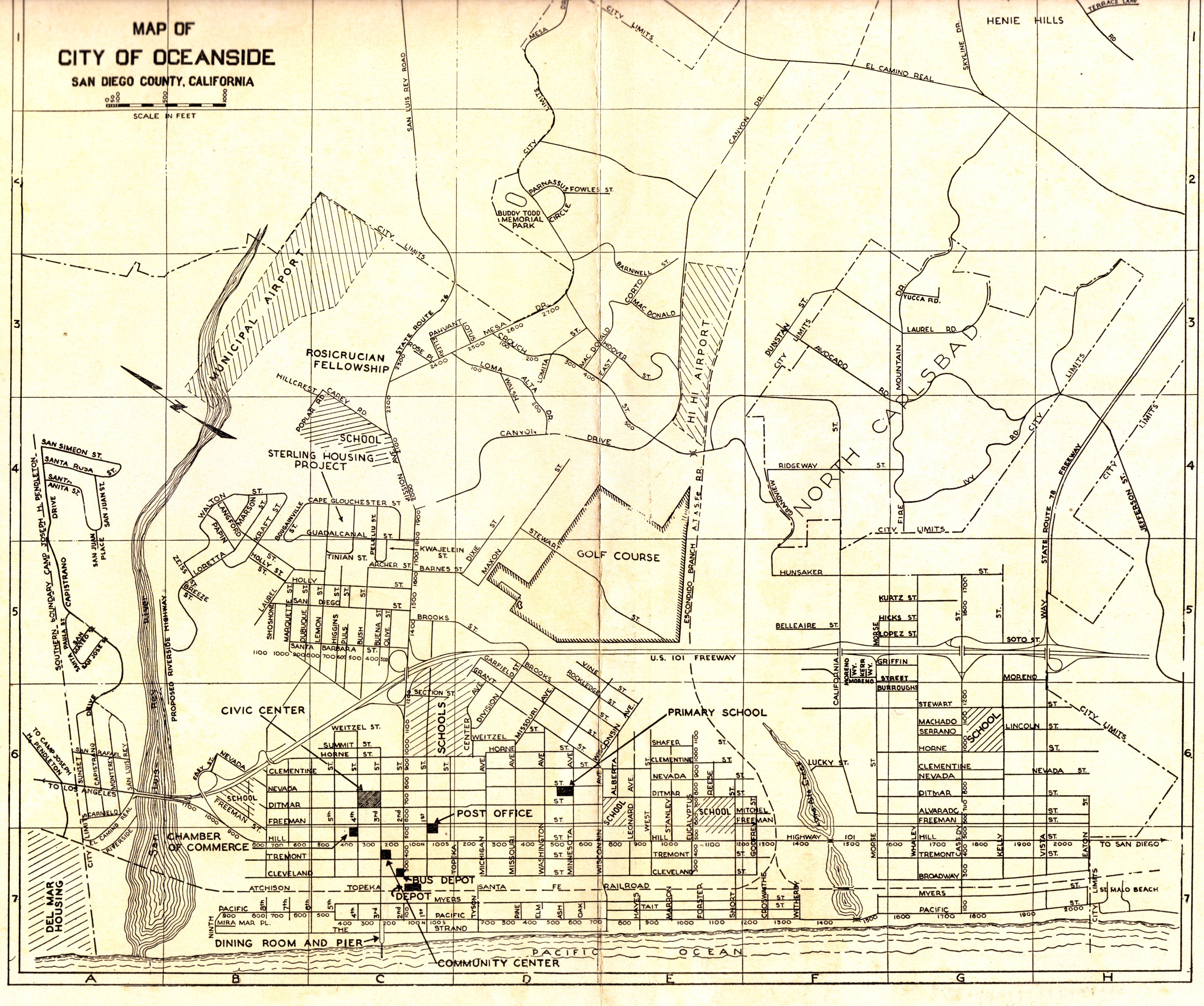

October 10, 2008 at 4:03 am
Interesting. Apparently Oceanside Blvd didn’t exist in 1956; it was laid over “Short St” and then extended east. I love old maps.
October 11, 2008 at 6:13 am
Yes, which is why the little used car dealership at Ditmar and O’side Blvd for decades was Short Street Motors. Also, down along industry past Crouch Street was the Hi Hi Airport. An older member of my church has regaled me with stories of flying out of Hi Hi when he was a young man.
October 26, 2008 at 11:37 pm
I often wondered why there were so many pine trees clustered at the west end of Eternal Hills–right against the hill where Knoll Street is. Was it a planting of Christmas trees? Longtime residents tell me that there was a dairy there, but no one knows about the pines. It’s a mystery.
October 31, 2008 at 12:13 am
Also interesting on this map is that Fire Mountain used to be considered “North Carlsbad.” Does anyone know where the name Fire Mountain comes from?
November 3, 2008 at 6:02 pm
One theory about the name Fire Mountain is that the Native Americans used the knoll (at the end of Knoll Road) as a signal tower, to signal from the surrounding mountains with fire. It’s easy to see how this could occur–but I have no clear evidence…..
December 9, 2008 at 4:36 am
Aunt Kristy: I’ve lived in Sklylark Terrace on Cornish Dr since 1963, since I was 10 and hiked all over the Eternal Hills property from El Camino Real to Cornish and the RR tracks to Fire Mountain. Those pines were never there growing up and were planted when the Fire Mtn Park was operational in the early 70’s. My high school girlfriend at the time was the summer program coordinator for the local kids during the few years the Parks and Rec serviced the park. I recall all the landscaping they did at the time. It was a nice place. Also, the Indian origin for Fire Mtn is pausable, my grandfather told me the reason Fire Mtn Road was winded back and forth was an old Indian switch-back trail so they could see if they were being followed. There must of been some scrub oaks at one time hence the grinding holes at the archeological site.
December 23, 2009 at 2:27 am
Regarding the name of Fire Mountain, I hadn’t heard the Indian/smoke story. Someone told me there was a landfill (dump) up here in the 40-50’s and they burned the trash. Not as romantic, but perhaps a bit more realistic. Or maybe just a nasty rumor started by residents of Henie Hills…….Either way it’s the best neighborhood in Oceanside and maybe that’s why the trees grow so tall.
August 5, 2010 at 9:10 pm
I just read the post on the pine trees, we have a few large ones on our property on downs that my great grandfather planted in the 50’s. He told us that a local bank he joined was giving out small pine tree plants to anybody who joined and they ended up giving him 8 total. This could be why there are so many in the area that are big and beautiful….?
August 6, 2010 at 6:40 pm
Hi
I’m new to this site, though I have lived on Fire Mountain for over seven years. I really like the site, there is information here that I never knew about until today.
I had no idea that there was an archeological site, but am not surprised as we have found stones with what look like human work on them.
Where is the archeological site?
Thanks
August 12, 2010 at 5:12 am
Great site! I’ve been looking for the Fire Mountain history for quite a while. Looking forward to the BBQ on the 21st. Thanks for the information and Fire Mountain PRIDE.
August 24, 2010 at 5:42 pm
The Fire Mountain neighborhood is the greatest neighborhood I have ever lived in. I lived in this area from 1977 to 1997, my kids were raised here and went to Palmquist Elementary, Lincoln Middle School & El Camino High School, it will always be home to us. The ruralness of the area is what attracted us to the area. We rented for all those years and moved to Riverside County near Temecula to purchase our first home. The neighbors all looked out after one another and were more like family than neighbors. When we first moved into the area there were still horses in several backyards. Enjoy this wonderful area.
December 30, 2010 at 2:53 am
I was told that it was called fire mountain because there used to be a fire station on yucca road just across Fire Mtn. Dr. from the water tower. Not sure if this is true or not since there’s no fire station on that map from 1956. When I went to school at Lincoln, teachers talked about how there once was ranch houses where the school is now. anyone know anything about this?
August 23, 2011 at 4:31 pm
I grew up on Crestridge Dr. beginning with it’s development in 1959. During The Great Depression my grandfather, Ralph Downs, traded his service station in Long Beach for property in the Fire Mountain area. The city of Oceanside disected the property with a street, naming it Downs. My father, James Downs and his family, lived on a farm during the 40’s which is now the cul de sac on Crestridge Dr. Shortly after my family moved to Crestridge from Carlsbad, contruction of Dunstan continued west. (steepest city street in O’side). This was known as “The New Road”. We all called it such for 30 years! My parents live there to this day.
August 24, 2011 at 3:03 am
I lived on Fire Mountain where Downs St. is now. Was a private drive surrounded by trees and farms. Father bought a barn from either Lincoln or Palmquest before schools were built.
October 10, 2011 at 8:29 pm
OK, I heard from the grandson of an elderly homeowner here that Fire Mountain is named such because it was the location of a former brick factory located at the crest of Fire Mountain Road near Yucca. And the fire from the kiln could be see for miles. Add this to the folklore list.
October 19, 2011 at 10:30 pm
Hi I’m currently on Palmquist’s PTO and we are trying to get a History of the school. Anyone that has details, stories, pictures that would be willing to share please contact me at tsheldon@cox.net with Palmquist in the title or feel free to post on our FB Group. Thanks!
April 22, 2012 at 8:43 pm
WOW.. I am amazed .. I lived across the street from Mike Alcorn. Mike Please email me your contact info
chrisdesmit@yahoo.com I grew up in the area from 1966 to 1976 and had friends there until we moved to Vista in 1976
April 23, 2012 at 3:52 pm
Anyone remember the Leader of the Muscaleros that lived at the end of Skylark in the Apartments? He died in early 1970’s around KDUE Near Garrison School? I remember all the motorcycles at Eternal Hills Mortuary.
December 13, 2012 at 7:05 am
LOL, I never made the connection .. Mr. Downs.. El Camino HS drivers ed.. Yellow VW Bug.. just before the steepest part of “The New Road”. The Airport office has some photos of Oceanside looking towards the Crouch St. switch back as it climbs, from the early 1960’s when the runway was moved to this side of the river.
The intersection of Canyon Dr. is the Y split at Oceanside Blvd. because Canyon ran from where it starts at Bush St. down the hill and if you imagine Oceanside Blvd. not existing, the road was called Canyon Drive all the way until it ended near the Silica Sand pit. When Short St. was pushed through east of Ditmar & Nevada St. and renamed Oceanside Blvd., it took over the right of way for Canyon Drive where it intersected resulting in that Y.
The address for the 7-Eleven store at Ditmar and Oceanside Blvd., is 711 Oceanside Blvd.
The I-5 Freeway was originally built as the “Oceanside-Carlsbad Freeway”, as a “rural bypass” because how you see traffic bunching up from the rest area into Oceanside and again passing Tamarack and Canon before breaking up at Palomar Airport Rd., the same thing used to happen on US-101 (Hill St.) and the freeway was built to bypass that. If you can imagine the current route of I-5 being “rural”.. When I-5 was planned, they used the Oceanside-Carlsbad Freeway as part of it and just expanded it to 4 lanes.
That freeway ended where Palomar Airport Rd. intersects with Carlsbad Blvd., and the bridge over the railroad tracks, the loopback and the used to be bridge for Ponto Drive, were all part of it.
March 9, 2013 at 11:33 pm
The archeological site is a triangular ridge near the reservoir. Eternal Hills used to let the public on the property but it’s fenced off now. They said that the site would be fenced from the cemetery to protect it as the cemetery expanded towards the site. But the nearby area is also considered a Native American Indian site so it may remain in its present state for some time to come. The local Luiseño Indians monitor activity there to prevent desecration and handle any remains that might be uncovered during cemetery expansion. It’s best left undisturbed for now. If the city ever changes its mind and decides to restore the Fire Mountain Park (now closed) that sits next to the site, perhaps Eternal Hills would allow access via the restored park.
August 23, 2013 at 3:01 pm
Wow! I never knew that Chuck. I grew up on these rocks. We used to play, dig, wonder who had made these structures and never knew. To think we were playing on and near a potential Archeological site it interesting.. I can still picture the structures there and where they were.. When I returned years ago to the area and saw that everything was fenced off and that the playground and basketball court, baseball field and where I grew up, I was totally surprised. Maybe someday they will allow us to go back there and I can then see what I played near growing up..
August 23, 2013 at 4:39 pm
You say Prop 13 shut the park, yet I moved into CA in 1980, and was near Gemco until 1984, when we moved over to behind Lincoln Jr. High.
I know I visited that park, even a few years after the houses on Knoll Dr. were built, and after moving closer to the area. It was a cool “shortcut” via bicycle to get to Crouch St. from Fire Mountain Dr., going over to Skylark.
Perhaps it was open and languishing before they finally padlocked the gate and took down the sign.
The amusing thing is that whole area at the bottom of Downs St. near Skylark is supposed to be a park, according to the city. With tables and an area to play. There’s nothing there except a dry creek, garbage and brush. You can’t do anything in there.
“Originally named for its location on Skylark Drive, the park was renamed in 1990 for Joseph Carrasco for his numerous contributions to the development of the park”
http://www.ci.oceanside.ca.us/gov/ns/parks/amenities/parks.asp#35
Are they kidding?
November 5, 2013 at 7:04 pm
My grandparents owned the property corner of Fire mt and laurel. They owned the property fromk the corner to the 4th house down The Jones’ of Jones furniture downtown 1940’s)Fire Mountain and the property on Laurel from the corner to the Multi colored hose (The Nadels)
When Grandma died I went through old letters and they were mailed to Oregon St. North Carlsbad.
My grandparents grew Avocados and raised chickens and ducks.
Granndma sold the chickens and eggs to the Twin Inns. Does anybody remember the Sunday special???? Chicken dinner…..We all had incenerators on each property, we all burned our trash and once a month we would take the glass and cans to a local dump. It was the property on the corner of Baily and laurel and it went down to the stop sign (Rudde St) The old guy that owned the property was named MEE, we called him old man Mee.Later his family took over the house. The family had twins we called them the Clark twins, they are still around.
But the “Fire” in Fire Mt might be because of all the Avo groves up here on Laurel Rd. Grandpa always had a pile of leaves smoldering for days at a time, he would rake for 2 or 3 days then Burn for 2 or 3 days. so did all the grove owners. plus the trash we all burned…….. Think?
November 5, 2013 at 7:07 pm
The point of the message was that Fire Mt at one time was Oregon st… (calif st, Nevada st. ,etc etc.)
November 5, 2013 at 10:23 pm
I’ve heard of Oregon St. reference in the area, but never saw it depicted anywhere. I wondered if it was perhaps in the valley below where Industry St and Oceanside Blvd. are, perhaps in the era when there was an airport near what used to be Phillips Carpet, at Camelot & Industry. The thought that something was renamed occurred to me.. but what?
.. guess that might be the answer.
May 9, 2015 at 5:04 pm
I grew up at 2260 Ivy rd. My grandfather bought that land in 1938. We sold the strawberry field land to the Williamsons as well as the land to build thier house. My father grew up at 2260 as well and I was born in 1968. The current house was built by my father Gordon in 1974. I have lots of memories from that era. We moved to different F-mtn prop in 1987. Father now deceased and mother moved away. I still live in area in Fire mtn apartments. Went to Palmquist, Lincoln, El Camino, then Mira Costa. I know lots of people in Fire mtn that have lived here a long time. Cried when Wal-Mart Center was built as my friends and I played there since kindergarten. Please correspond.
May 9, 2015 at 11:07 pm
I have combed over the old nursery by Fire mtn park for years. Not supposed to go in now I guess but I have found artifacts there. Stone flakes and shell middens. When the archaeologists last came around 2000 or so I was surprised to be told the artifacts they were focusing on were about 2000 yrs old. They said Native Americans were last there around 200 to 300 yrs ago but there was a presence there for thousands. Btw, I had heard Fire Mountain got its name because the red sandstone at the Fire Mtn park area looked like fire from a distance when the sun hit just right.
June 6, 2015 at 3:33 pm
I caught a glimpse of a very old map at City of Oceanside Engineering Dept. years ago. It did have Oregon Road where Fire Mountain Rd is now. I’m glad I saw the comment about Oregon Road. I was beginning to think I dreamed it! No one I asked seemed to remember until now!
August 5, 2015 at 2:48 am
I own a condo in La Montana (just west of the Presbyterian Church). To the left of the driveway as you come in is something which a friend of mine identified as a mooring for a dirigible. Can anyone back this up, or explain what it’s doing there?
November 14, 2015 at 2:45 am
Re. FIRE Mountain name, I have this to add. I have old maps surveyed in 1898, printed in 1901 and 1920. They show Fire Mountain. No roads on or to the mountain. South O, near the coast, is depicted with roads.
December 19, 2015 at 2:42 am
My understanding is that Fire Mountain was the fire break between Carlsbad and Oceanside. The two cities were always in dispute whose responsibility to cover the fires in that area. I had an old gardener friend (Jerry Wallace) who lived on Laurel Rd. I used the Carlsbad address to send him a Christmas card one year (probably 50 yrs. ago) and the card never got delivered because it was decided Laurel was Oceanside’s domain.
May 12, 2016 at 5:24 am
I remember the entire area around the water tank growing up in the early 60’s. There were no houses on Cornwall, Knoll or Eldean nor the south side of Dunstan where it drops down from Laurel to Sarbonne. The Tinch’s owned the property to the west of the tank and there was no “park” at the time. At the end of Dunstan before it was expanded for Knoll and Eldean, there was a underground tunnel running east to west created by a seasonal underground stream coming off the water tank hill to the NE that started at the top; we used to drop into it about 6-8 feet down, crawl probably 150′ and pop up about 50′ from where Dunstan connected to Sarbonne. We used to go up around the water tank where there was a wild gourd field growing 3-4′ green/yellow gourds and have “gourd” fights. Man they hurt when they hit you. Also the area was great for dirt clod fights as there were small crevices coursing through the area north of the water tower where we played WW1 style trench warfare. The “ridge shooting north off the water tank was a high as the house roof tops along Knoll. They graded it all down and pushed it over to the east to make the pads on Eldean. Before grading for Knoll and Eldean, the “Hill” as we kids called it was covered with mounds of asphalt presumably left over from when they paved Skylark Terrace. Those black mounds would heat up and all kinds of reptiles (scorpions, centipedes, horny toads, king, gopher and rattle snakes would come out to sun. It was a kid’s field day to collect all the critters to our mother’s “you’re not bringing those things into my house!” I remember watching guys in WW2 jeeps trying to climb up the steep hill sides at the end of Skylark from the rail road tracks and sliding down the same hillsides on cardboard “sleds” when the anise and cane dried out in the summer. We rocketed our Schwinn Stingray bikes up and down the “canyon” and in N out of the crevices between Cornish and El Camino. Last bit of nostalgia tonight, in the mid-60’s we use to get up early before sunrise to rabbit hunt with fiberglass bows and practice-tipped arrows on the cemetery lawn (there was only one lawn then surrounding the old tudor style building in the middle of the current property). The rabbits loved all the grass and dozens would show up at dawn. We’d sit up on the shoulders of the statues and fire away. Never got a rabbit , so you can guess what a bad shot I was. Had to get down and out before the grounds keepers showed up for work or they’d turn the sprinklers on us to chase us off. Climbing up the back of the hill below Eldean soaking wet was not fun in wet jeans, very chaffing if you get what I mean. Lots more to reminisce on at a later time, especially playing in the creek. early Palmquist, Lincoln stories, watermelon raids, Carlsbad Forest, the lagoon, Silica Sand company’s “lake”, the rail road tracks, etc. Best place to grow up in my book.
April 5, 2017 at 4:56 pm
My dad’s lot was #35 on the corner of Fire Mountain Dr and Laurel Road. South Coast Land Co sold it to his parents in 1931. Dad’s name was Gene Merkurieff. His mom used the name Nellie/or Petronella/or Kira Ruman. She was a beauty salon operator at 418 East Grand and then 150 East Grand in Escondido. Anyone ever hear of them? When did South Coast Land acquire and divide Fire Mountain area/North Carlsbad? Would love to know…
jmneilson@comcast.net
April 5, 2017 at 6:29 pm
My dad’s lot was #35 on the corner of Fire Mountain Dr and Laurel Road. South Coast Land Co sold it to his parents in 1931. Dad’s name was Gene Merkurieff. His mom used the name Nellie/or Petronella/or Kira Ruman. She was a beauty salon operator at 418 East Grand and then 150 East Grand in Escondido. Anyone ever hear of them? When did South Coast Land acquire and divide Fire Mountain area/North Carlsbad? Would love to know…
jmneilson@comcast.net
July 29, 2017 at 5:43 am
My grand parents lived at 1734 Fire Mt. Dr. from the mid 50’s to the early 80’s until my parents purchased the property from them which is located directly behind Palmquist Elementary School at the very west end of Fire Mountain Dr. It was a chicken ranch before my grandparents purchase of the property and for a good portion of their time there it was part of N. Carlsbad before Oceanside and Carlsbad did the exchange. My mom went to Carlsbad H.S. and my dad went to Oceanside H.S. As a kid hanging out at the grandparents house it was a blast. There was an old lath house with incubaters and stuff left over from when it was a chicken ranch and fields and gully’s to play in everywhere. Before Palmquist Elementary school was built my grandparents property extended out to what is part of the schools grass play area. There was an eminent domain which my grandparents were given $3000 for a portion of their 5 acres. That land along with a good portion of the rest of their property was full of avocado trees and avocados were going to be the family business until the school did the eminent domain and wiped out many of the trees.(rrrr) My grandfather over the years sold off parcels and built a couple of homes and sold those too which were once part of their land. There are six homes there now. There’s approximately 2 acres left to which my parents still live, are retired and are enjoying the openness and privacy the approximate 2 acres gives them. My grandparents were Ken and Hazel Jensen. They were the original owners of Scandia bakery which was located near Coast Hwy (Hill St.) and Mission Avenue. The story I was told was that another bakery moved in next to theirs, they threatened to put my grandparents out of business unless they sold them their business. My grandparents agreed to sell, they were honestly burned out from living, eating, breathing the business. And the other baker ended up going out of business sometime later. (Devine Intervention) I saw a post on here about the Oceanside biker club “The Muskaleros”. My dad’s cousin was the vice president back in the day, his aka was “Animal”. He had his own dojo and is a black belt in martial arts. I’ve heard stories and have been told they were and are a pretty hardcore group. Anyway, I was lucky to have grown up on Fire Mountain. It will always be my stomping grounds.
November 14, 2017 at 10:47 pm
Arrived here researching a relative who died in 1956 in Oceanside. All I know is he was a firefighter, so I was looking for a history of fires in Oceanside.
All I find are notes about Fire Mountain, questions about why there weren’t any trees, and people took the initiative to plant a lot of them. Maybe, fires burned down a lot of trees, especially with all the references to a landfill, burning for garbage disposal as well as a steady kiln for bricks, and a fire station mentioned over near Yucca Road. Does any of that make sense?
I was trying to find out if the man died fighting a fire or how he died, but from the sounds of these memories I understand why there needed to be firefighters. It was interesting to hear of dysentery in the 40s and how poor the living conditions in the 50s during the Korean War.
January 19, 2018 at 2:16 am
My family lived at 2245 Ivy Road from 1951 to 1984, I watched May Co mall being built, Vista Way being turned into 78 and the Mervyns shopping center being built. I went to elementary school in Carlsbad and Junior High and High School in Oceanside after Oceanside annexed the area. I remember when the Sloops where house burned down and because we were considered county at the time and there was no mutual aid, the pumpers had to come from Del Mar and return there for water. There were two more fires over the years and the firemen were not sure if it was in Oceanside or Carlsbad. A little scary. We had chickens and burned our trash in a 50 gallon barrel. I loved growing up there and was sad when we sold. I didn’t want to miss the view. That was before Walmart went in. Instead of a view of the lagoon, I would have a great view of McDonalds! I do miss the Canadian geese flying over.
December 27, 2020 at 2:02 pm
Hi! My name is Paul Sloop. I grew up at 2260 Ivy Rd. My grandfather first built on that land in the early 1950’s. My dad continued on the property and we lived there until 1987. Then my dad built a house at 1811 Ivy Rd and we lived there until the mid 1990s. I know the Fire Mtn Posse well!
May 16, 2021 at 9:46 pm
I wonder if anybody can tell me if there is a street named ‘Ups” that intersects with “Downs” near the top of the hill. I lived in Oceanside for three years beginning in Jan 2001, and I recall going up the hill on Downs and seeing the street signs, Ups and Downs at a corner on the right. I used to think, Hmmm, the corner of Ups and Downs. Now, can anybody tell me if my memory is correct or fanciful imagination? Or both? Intending to stop and take a picture of those signs, I am quite certain that I did, but I never remember seeing the picture. It is one that I would like to see — a picture of that corner.
May 16, 2021 at 10:47 pm
You’re right, there is an Ups Circle off of Downs!
May 17, 2021 at 3:39 am
Ups is the first street north of Fire Mountain. BTW, Downs was named after the farmer who lived here, it was the road to their home. We discovered that when we met his son who owned the Grand Deli in Carlsbad